The Shape of Turned Earth: A Brown Coal Park for Südraum Leipzig, 1996.

LEFT: LEIPZIG LOOKING AT AN EXISTING MAP OF LAND USE ON THE TURNED EARTH LANDSCAPE AN IMAGE OF EXTREME FRAGMENTATION EMERGES WITH OPEN MINES IN BROWN FILLED AREAS IN OCRE ALL GREENS MEANING VEGETATION WHILE BRIGHT YELLOW MARKS LAND THAT HAS BEEN OPTIONED FOR MINING. RIGHT: THE MAP OF SOUTH LEIPZIG IS CLARIFIED AS A MUCH LARGER DOMAIN WHEN THE 160 SQ KM SHAPE OF THE EARTH TURNED OVER FROM MINING IS MAPPED. WITH THE OPEN PIT MINES AT WITZNITZ AS EXEMPLAR WHILE THE SHAPE OF THE WHOLE TAKES ON AN ICONIC PROPERTY.
The Shape of Turned Earth: A Brown Coal Park for Sudraum Leipzig proposes a new lake district for the 300 square kilometers of turned earth and excavation formed by open mining over a 50 year period. Our proposal was to build a renewed ecocultural landscape.
We were among several artists invited by the Cultural Foundation of the Free State of Saxony and the Cultural Program of the Siemens Corporation to travel to the “black” triangle made by the borders of Poland, the Czech Republic and Germany, to look at the brown coal open pit mines in order to see how artists might respond to that environment.
The idea of the park itself is as follows: The many excavations, adding up to about 50 square kilometers, become lakes as the water tables rise, some lakes toxic, some not.
The one near Witznitz Tagebau, although toxic, had, when we were working there, some of the most complex and diverse bird life in the whole region! On the matter of the turned earth, this earth resembles earth that has been scoured by a glacier so that all topsoil has been removed. After a time, in the first succession, a rather unattractive initial ecosystem moves in. The first sucession stage may be unattractive, but then, as trees, bushes, and other plants move in, it ends up as a unique sucession forest. Being patient and assisting the migration of appropriate species, while at the same time permitting this ecosystem to evolve by itself, would also add uniqueness to that which happens in the park, just as the arbitrary lakes do. After all, it took many years to destroy this place. Giving it some years to recover seems reasonable.

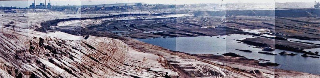
The design we made for Tagebau Witznitz, done at the request of the Mibrac Company takes a rather extreme position in shaping this 20 square kilometer excavation. The extreme position can be stated simply: the process of the excavation terminated all that was living, in the ecological sense and in the cultural sense. Our design, which is also unnatural artists (although Nature would never know this) sets out to carve a complex array of folds along the artist edge. The resulting diversity of habitat that would be formed would offer space for a great diversity of species.
In our own discussions years ago with land planners and the mayors of the region it became clear that northern Leipzig, with its industrial center and high-tech buildings and conference centers, had one form of identity, and Sudraum Leipzig could well be envisioned as a counterbalance, a new lake district, ultimately serene, meditative, quiet, with remarkable public parklands and housing embedded in it.
Then there is the matter of public lands. The Mibrac Company was given the land to mine by the government. Thus the ownership of this land was once in the public domain. We believe that the Mibrac Company should be encouraged, through the means of a tax deduction or whatever, to contribute the Lands of Turned Earth back to the public domain. If the Mibrac corporation’s ownership of the land is not clear, then we believed the city of Leipzig should reclaim these lands in the public interest.
This then became our proposal for South Leipzig, which was exhibited, reviewed and basically rejected by the Planning Department who were then in place.
Now, years later most excavations have become lakes as a result of the rising water table. They appear to be designed piecemeal as in the main recreation areas. No whole systems design appears.

LEFT: WHERE A COMPLEX ECOLOGICAL EXPERIMENT TRANSFORMS A BIOLOGICALLY IMPOVERSISHED EXISTING MINE CLOSURE DESIGN INTO A RICH EMERGENT ECOSYSTEM SIMPLY BY CREATING COMPLEX FOLDS IN THE EARTH AND EDGES. RIGHT: THE BROWN COAL REGION OF SOUTH LEIPZIG BECOMES A LAKE DISTRICT FRAMED WITHIN A BIODIVERSE FIELD AS THE WATER TABLE RISES FILLLING THE EXCAVATIONS. WHEN THE WATER TABLE RISES ECOLOGICAL CONTINUITY IS CREATED BY PERMITTING THE SUCESSIONECOSYSTEM THAT HAPPENS AS A CONSEQUENCE OF TURNED EARTHS.